|
PAST |
June 28,
2001 |
NEXT |
 |
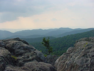
* Blue Ridge Mountains *
The Blue Ridge Parkway runs along the top of
the Blue Ridge Mountains
which is actually part of the Appalachian Mountains on the East
coast here
in the U.S.. Of course many of you from the West coast and other
parts of
the world may laugh at the fact that they call these little hills
mountains
since the highest peak is a mere 6,684 feet and they all average
from 2,000
to 4,000 feet and the range is only about 5 to 65 miles wide. The
Blue Ridge
Mountains extends southward for 615 miles from Carlisle in
Pennsylvania to
Mt. Oglethorpe, Georgia.
Primarily here in Virginia, the Blue Ridge
Parkway is a total of 469
miles long and is a nice drive as it traverses the tops of the
mountain
range. As you drive down the parkway you pop back and forth from
an East to
a West view. This picture was actually looking Westward.
There are lots of plants and animals and like
the black bear picture
from yesterday you will be seeing quite a few shots that I got
out of the
total 184 pictures that I took on Monday afternoon.
184 pictures, don't you just love digital
cameras?
Unfortunately the wildlife there seemed a
little too familiar with
humans as they didn't appear to be very alarmed at our presence.
I actually
had to yell at a deer to stop grazing and turn around so I could
get a good
picture.
I think that the bear wanted to go home with
me. Or eat my leg.
I couldn't tell.