 |
PAST |
August 30,
2001 |
NEXT |
 |
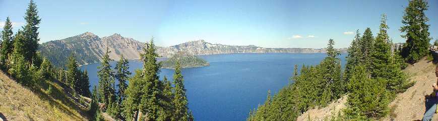
* Crater Lake *
In Southern Oregon, in the Cascade Mountains
remains one of the most
incredible sights I have ever seen. You can stand along the edge
of this
wonder and still not believe that you are truly looking at it.
It's as if
somebody put a gigantic painting right out there in the
mountains.
Crater Lake is an amazing geographical oddity.
It was formed about 7,700
years ago when the volcano, Mount Mazama blew up in a cataclysmic
eruption.
Prior to this event Mount Mazama was estimated to be
approximately 12,000
feet tall. Much like the blast of Mount Saint Helens on May 18,
1980 the
whole top of the mountain was blown away, leaving a huge crater.
However,
unlike Mt. St. Helens the remaining sides of the mountain
remained
completely around the perimeter. With the walls of the crater
intact there
was no way for future snow and rain water to escape so it filled
up over
time. Still active, the magma under the surface created the peak
inside the
crater known as Wizard Island.
At a current depth of 1,947 feet, Crater Lake
is the deepest lake in the
United States. Due to seasonal issues this depth, of course, will
change
somewhat.
Because there are no streams entering or
leaving the crater the water
contained no fish until introduced by humans from 1888 to 1941.
The water retains an incredible deep blue
color that almost seems
unnatural. No matter what I did my camera could not truly capture
this
intense, brilliant color.
Even with my wide angle lens I was not able to
capture the whole lake
into one view so here I have easily stitched three pictures
together to
create a small panoramic view. Please ask for some of the full
size images.
They are amazing.